 FOX.35.Digital.Staff@fox.com (FOX 35 Digital Staff)
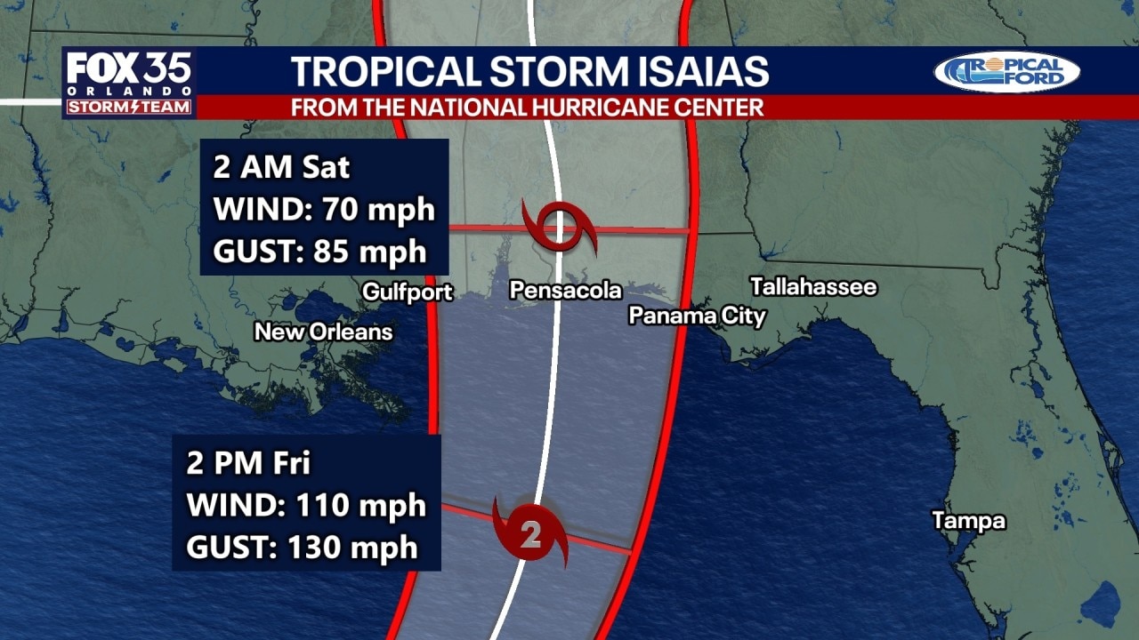

Tropical Storm Isaias strengthened into a hurricane late Wednesday evening. With a projected track that is targeting the northern Gulf Coast, forecasters are warning of dangerous coastal flooding, damaging winds and heavy rain.
Isaias is the ninth named storm of the 2026 Atlantic hurricane season.
The storm is expected to pass north of Mexico’s Yucatán Peninsula on Thursday before turning north toward the U.S. Gulf Coast. Forecasters expect landfall late Friday or early Saturday.
Will Isais impact Florida?
What’s next:
Isaias does not pose a direct threat to Orlando, Tampa or much of Central Florida, though parts of the Florida Panhandle remain in the storm’s forecast path.
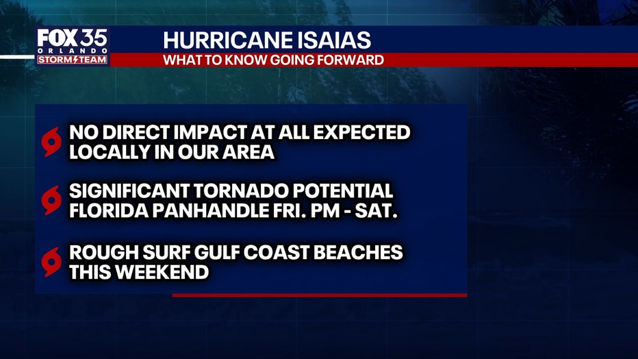
For Central Florida, the main impact will be additional heavy rain following an already unusually wet stretch.
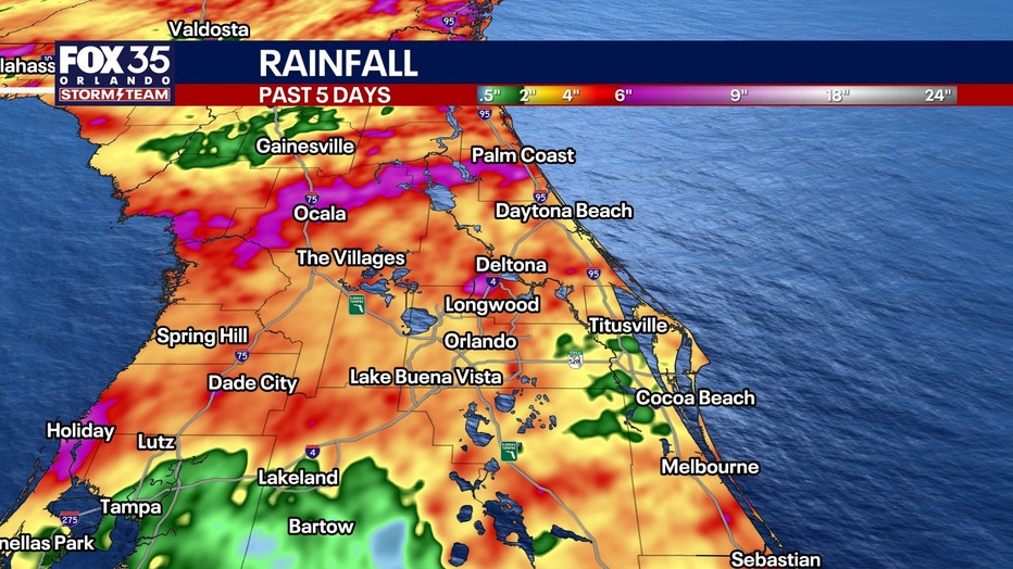
More than 9 inches of rain has fallen over the past five days in parts of Heathrow and Lake Mary, Flagler Beach and northern Ocala. The dramatic shift comes after an exceptionally dry start to the year: Before the recent rainfall, Orlando was experiencing its driest year-to-date period since records began in 1892.
Hurricane, tropical storm watches issued
Big picture view:
A hurricane watch is in effect from Bay St. Louis, Mississippi, to Indian Pass, Florida. Hurricane conditions are possible in that area by late Friday.
A tropical storm watch is in effect from the Jefferson-Plaquemines Parish line in Louisiana to west of Bay St. Louis, as well as from east of Indian Pass to the Aucilla River in Florida.
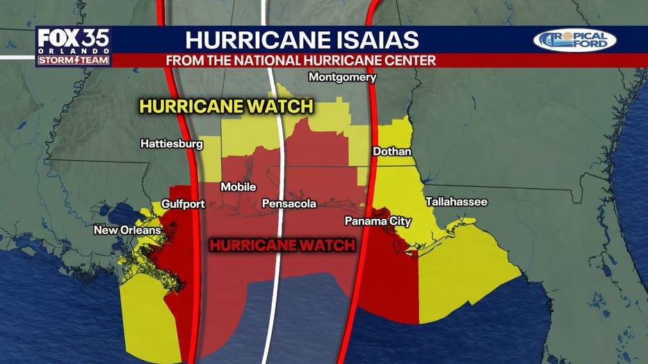
Tropical storm conditions could begin in parts of the watch area by midday Friday.
A storm surge watch extends from the mouth of the Mississippi River to Yankeetown, Florida, meaning dangerous coastal flooding is possible within 48 hours.
Additional watches or warnings could be issued along the northern Gulf Coast.
Isaias strengthens into Cat. 1 hurricane
Timeline:
An Air Force Reserve Hurricane Hunter aircraft confirmed the storm had reached hurricane strength late Wednesday.
In a rare 11:30 p.m. advisory from the National Hurricane Center, Isaias was about 180 miles northwest of Progreso, Mexico, and about 460 miles south-southwest of the mouth of the Mississippi River.
The storm was moving east-northeast at 9 mph. Forecasters said winds were sustained at 75 mph, with stronger gusts.
The National Hurricane Center reported the storm’s central pressure at 982 millibars.
Tropical storm-force winds are expected to extend over a hundred miles from the center.
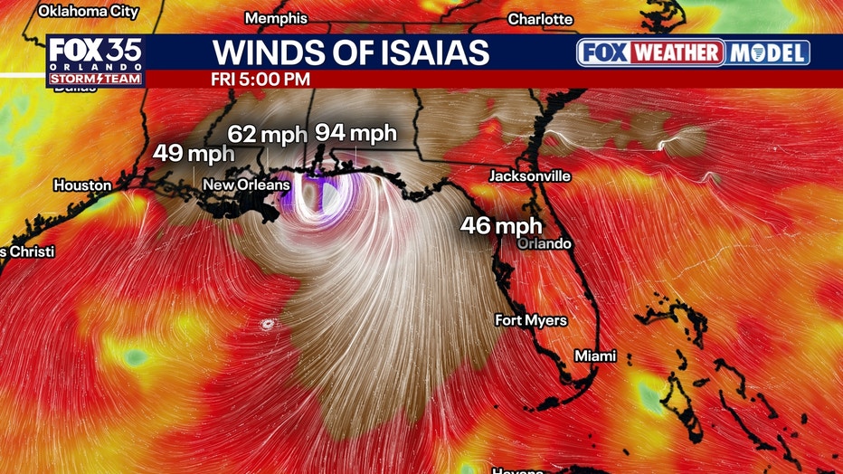
Remnant rains, winds, and isolated tornadoes will spread inland into Alabama, Georgia, and Tennessee Saturday into Sunday.
Dangerous coastal flooding possible
Why you should care:
Storm surge could push water 5 to 7 feet above normally dry ground from Ocean Springs, Mississippi, to Indian Pass, Florida, including Mobile Bay.
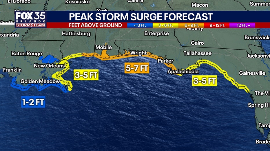
The highest water levels are expected near and east of where the storm comes ashore. Large and dangerous waves could make coastal flooding worse.
Heavy rain raises flooding threat
Isaias could bring 3 to 7 inches of rain from southeastern Louisiana to the Florida Panhandle from Friday through the weekend. Some areas could receive as much as 10 inches.
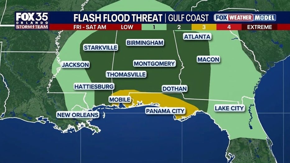
Much of the Southeast, including areas as far north as the Tennessee Valley and Carolinas, could receive 1 to 3 inches, with isolated totals of up to 5 inches.
Heavy rain could cause flash flooding, street flooding and isolated river flooding.
Tornado threat could increase Friday
The risk of tornadoes is expected to increase along the northeastern Gulf Coast on Friday evening and overnight as bands of storms move ashore.
The tornado threat could spread farther inland Saturday as Isaias moves north.
Dangerous surf and rip currents expected
Large waves are expected to develop around the western and northern Yucatán Peninsula on Thursday before spreading toward the U.S. Gulf Coast later in the week.
The waves could create dangerous surf and life-threatening rip currents along affected beaches.
Residents should continue checking updates from the National Hurricane Center and their local National Weather Service office as the storm approaches.
Florida State of Emergencies
Local perspective:
Florida Gov. Ron DeSantis on Tuesday declared a state of emergency for 25 counties: Baker, Bay, Calhoun, Columbia, Dixie, Escambia, Franklin, Gadsden, Gilchrist, Gulf, Hamilton, Holmes, Jackson, Jefferson, Lafayette, Leon, Liberty, Madison, Okaloosa, Santa Rosa, Suwannee, Taylor, Walton, Wakulla, and Washington.
Gov. DeSantis said the Florida State Emergency Response Team (SERT) is preparing resources in Tallahassee and Santa Rosa areas, including generators, fuel, flood barriers, box water pallets, shelf-stable meals, flood buckets, tarps, tiger dams, and sandbags.
The Source: This story was written based on information from the National Hurricane Center and the FOX 35 Storm Team.
Source link
FOX.35.Digital.Staff@fox.com (FOX 35 Digital Staff) Hurricane Isaias live tracker: path, forecast, Florida state of emergencies www.fox10phoenix.com
Latest News | FOX 10 2026-10-08 04:08:37
+



GIPHY App Key not set. Please check settings